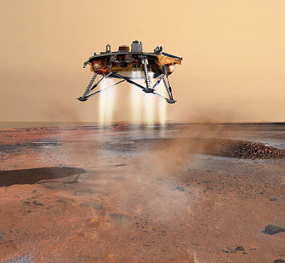
The Phoenix ground drone was
successfully launched from the Cape Canaveral Air Force Base in Florida, the USA on
August 4, 2007, by a Delta II rocket by the University of Arizona with the
support of the NASA Research Centre. The Phoenix is an unmanned aerial vehicle
(UAV) launched into space to explore Mars. The Phoenix scale landed on Tuesday,
May 25, 2008. It is a joint venture between the universities of the United
States, Canada, Switzerland, and Germany, NASA, and the Canadian Space Research Centre.
The spacecraft landed on the frozen north end of Mars and drilled soil with
robotic hands. The Phoenix spacecraft is 18 feet long and 5 feet wide.
Tools located on the Phoenix
scale
1. Robotic Arm
The pit was drilled to a depth of
seven and a half feet. Take the test equipment and place it in the appropriate
place. Transfer to other tools to study soil samples.
2. Surface Stereoscopic Imager
The camera, located on a scaled
pole, captures a spectacular view of the Martian atmosphere. The other camera
captures the base color.
3. Meteorological Station
Arrangement to record day and
night climates regarding the temperature, pressure, and wind speed of the Mars
site.
4. Microscopy, Electrochemistry & Conductivity Analyzers
Four chemical tools to test Mars
soil samples.
5. Mars Descent Imager
The device captures how the scale
separates from the spacecraft and keeps track of the motion as it descends into
the gravitational field of Mars.
6. Thermal & Evolved Gas Analyzers
A device that detects
carbon-based samples and tests their chemical properties.

Mars is a planet in the Solar
System. This is the fourth sphere of the sun. Mars is the second smallest
planet in the family after Mercury. The Manatees named the planet after the god
of war. The iron oxide found on its surface makes the planet red. Hence the
name Mars. A geospatial surface, it has craters like the moon, volcanoes,
valleys, deserts, and icy Polar Regions similar to those on Earth. The orbits
and seasons of Mars are similar to those of Earth. The tallest Olympus Mountain
in the solar system and the Mariner Valley, one of the largest vertical
valleys, are located on Mars.
Until Mariner 4 successfully flew
close to Mars in 1965, it was believed that there would be liquid water on the
surface of Mars. Such optimism was due to the black and white signs that change
over time near the polar regions of the planet. These were thought to be seas
and continents. It was also thought that the long dark scratches found on the
surface may have been from irrigation canals. This was later interpreted as an
optical illusion. However, geological evidence collected by unmanned missions
shows that there was once a large amount of water on Mars. It has two moons,
Phobos and Times. These are small and irregularly shaped. Like Mars 'Trojan
asteroid 5261 Eureka, these may be asteroids attracted by Mars' gravity.

The Phoenix scale landed on
Tuesday, May 25, 2008. Phoenix entered the Martian atmosphere at a speed of
approximately 21,000 km / h (13,000 mph). And within 7 minutes reduced its
speed to 8 km / h (5.0 mph). Atmospheric entry was confirmed at 4:46 p.m. Radio
signals were received at 4:53:44 p.m. Unlike some of the other places visited
with landers on Mars, all the rocks near Phoenix are small. As far as the
camera can see, the ground is flat, but shaped into polygons 2-3 m (6.6-9.8 ft)
in diameter and surrounded by grooves 20 to 50 cm (7.9 to 19.7 in) deep. These
patterns are caused by the expansion of ice in the soil and the contraction by
large temperature changes. The microscope showed that the soil on top of the
polygons was made up of flat particles (probably a type of clay) and rounded
particles. Also, unlike other places visited on Mars, there are no dunes on the
site. The ice is a few inches below the center of the polygon, with ice at
least 20 cm (8 inches) deep at its edges. It slowly rose when ice was exposed
in the atmosphere of Mars.
Source: Wikipedia
Information: Dr. P. Ramesh, Assistant
Professor of Physics, Nehru Memorial College, Puthanampatti, Trichy.
Get information like this
Get information like this
https://t.me/joinchat/jpqj3jQLN51kYTk9
Join Telegram Group.
https://chat.whatsapp.com/HHC5m0Jz3Ue1E8ilgta0YT
Join WhatsApp Group
Thanks.
Also, Read
🛑👍 CSIR-NET Physics Materials and Problems
🛑📕 21 GB and Hundreds of Physics E-Books Collection.
🛑🛥️ How does an Electric Motor work? (DC Motor).
🛑🤹♂️ Science Academies' Summer Research Fellowship Programme for Students and Teachers 2022.
🛑🔌 How does a Transformer work - Working Principle electrical engineering.
🛑🎙️ Transistors Explained - How transistors work.
🛑🔥⚡ How Thermocouples Work - basic working principle.
🛑🔌 Voltage Explained - What is Voltage? Basic electricity potential difference
🛑🔌 What is CURRENT– electric current explained, electricity basics.


.png)
.jpg)
No comments:
Post a Comment